|
Climate Information
(US Weather Service
Spotter Station AZ-709) |
Weather
Photos |
|
Weather and Climate have a
critical effect on growth of cacti and succulent plants. I am
fortunate to live in a succulent rich ecosystem with a climate favorable to the
growth of many types of cacti & succulents from around the world. This is the
Arizona Upland subdivision of the Sonoran Desert, which is
characterized by 5 seasons. Although the climate is generally warm to
hot,
dry, and sunny, it presents its own set of complications for growing
cacti and succulents. In particular, the combination of heat, aridity,
and sun intensity are either fatal or
disfiguring to unadapted (or unadaptable) plants exposed to the elements.
Because of the extremely high UV content of sunlight, most growers in
this region keep plants under at least 25--50% shade cloth all year round. |
|
According to contemporary
interpretation, the Arizona Upland subdivision of
the Sonoran Desert has 5 seasons. The 5th season is a splitting of
summer into a hot dry portion, known as the "arid fore-summer" and a
relatively short, hot humid portion known as the Arizona Summer
Monsoon. The Monsoon involves a seasonal shift of the prevailing winds
from westerly to generally easterly or southeasterly, thereby
importing moisture from the Sierra Madre of Mexico. It is during the
~2 month period of July and August that we receive about 1/2 our
annual precipitation in the form of short but intense thunderstorms.
These thunderstorms are convective and occupy small cells as compared
with frontal thunderstorms found in most areas of the world. There is
a secondary peak of rainfall during the December to February period
and the remaining months are generally dry. In fact, August usually
brings a number of stretches of 2 to 5 days during which the
prevailing wind switches to westerly and the dewpoint drops back into
the 20's or 30's Fahrenheit. Although the dewpoint reaches 54˚F and above during
July and August, the remainder of the year is characterized by very
dry--often bone dry--air. The average daily high at the coldest time
of year is in the low 60's and the average daily high in summer is in
the low to mid 100's Fahrenheit. A typical June or July daytime high
(in the shade) is about
105--108F (40--43˚C). The annual temperature extremes are between ~25˚F
(-4˚C) on at least 1 night
per winter and sometimes up to 120˚F (~50˚C) in late June. These temperatures
are measured by the standard method using a thermometer in the shade
and shielded from direct solar radiation. In the sun, at ground
level, it can reach ~180F (~80˚C) on some days. Somewhere I once read
Arizona summer described as "oven-like heat". This is true. |
|
|
Precipitation |
|
 |
2007:
Days with measurable
precipitation 0.01" or more: 2.
Total precipitation, 2007
calendar year: 0.18". |
|
 |
2006:
Days with measurable
precipitation 0.01" or more: 22.
Total precipitation, 2006
calendar year: 7.35". |
|
 |
2005:
Days with measurable
precipitation 0.01" or more: 21.
Total precipitation, 2005
calendar year: 10.52". |
|
 |
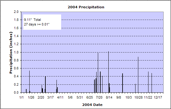
2004:
Days with measurable
precipitation 0.01" (0.25mm) or more: 27.
Total precipitation, 2004
calendar year: 9.11". |
 |
2002:
Days with measurable
precipitation 0.01" or more: 24.
Total precipitation, 2002
calendar year: 6.24"
Notice the peak rainfall during
the Arizona Summer Monsoon. During July and August, there were 15 days
with
precipitation during the ~60 day period of the "rainy season". |
|
 This
graph compares the monthly average precipitation at recording stations
near me and at the Weather Service Office at Tucson
Airport. These are 50 year averages. The name "Anvil" is a
ranch 5 miles southwest of my
location and "Tucson" refers to the Weather Service Office at the
Tucson Airport, 25 miles east. This
graph compares the monthly average precipitation at recording stations
near me and at the Weather Service Office at Tucson
Airport. These are 50 year averages. The name "Anvil" is a
ranch 5 miles southwest of my
location and "Tucson" refers to the Weather Service Office at the
Tucson Airport, 25 miles east. |
|
|
Temperature
Profile |
|
This graph shows the
temperature profile on a typical June day. Time is measured in
Mountain Standard Time (GMT - 7h).
The two curves compare the
temperature at my location (blue, 3201 feet elevation) and the Weather
Service Office (red, ~2500 feet elevation at the airport). Notice the
difference between my location in the open desert and the airport
which is 10 miles from the city center but still within the
temperature bubble known as the "urban head island". Because of the
bone dry air and lack of thermal inertia, my location heats up faster,
beginning earlier in the morning but also cools faster, beginning
earlier in the afternoon. Although the daily high is usually similar
at the 2 sites, the nighttime low at my location is typically 8˚F
(5˚C) cooler and is
reached earlier in the evening. |
|
|
Arrival of the
Monsoon Airmass
 An
important feature of the climate is the "5th season" known as the
Arizona Summer Monsoon, or just the "Monsoon". This weather pattern is
described above. The graph below shows the abrupt arrival of moist air
just before 8AM local time on 8 July 2002. For keeping records, the
monsoon season technically lasts from June 15 through September 30,
even though the average date of onset is 3 July and typically the
pattern dissipates by around 5 September. During the monsoon, there
are also usually 3 or 4 breaks of 2 to 3 days in which the humidity
drops to or near to regular levels. Some years the monsoon has trouble
both keeping the humidity up and offering more than a few
thunderstorms during that 2 month period. An
important feature of the climate is the "5th season" known as the
Arizona Summer Monsoon, or just the "Monsoon". This weather pattern is
described above. The graph below shows the abrupt arrival of moist air
just before 8AM local time on 8 July 2002. For keeping records, the
monsoon season technically lasts from June 15 through September 30,
even though the average date of onset is 3 July and typically the
pattern dissipates by around 5 September. During the monsoon, there
are also usually 3 or 4 breaks of 2 to 3 days in which the humidity
drops to or near to regular levels. Some years the monsoon has trouble
both keeping the humidity up and offering more than a few
thunderstorms during that 2 month period.
|
|
|
|
 The
National
Weather Service in Tucson makes observations at the Tucson
International Airport, about 25 miles to the east. The
National
Weather Service in Tucson makes observations at the Tucson
International Airport, about 25 miles to the east. |
|